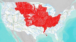
A New Online Tool from the Department of the Interior called Streamer
The US Department of the Interior has recently released a nifty online tool that they call Streamer. Depending on your objective, it can be a valuable research device or a lot of fun.
Streamer’s purpose is simple. It is an interactive map that allows you to trace a stream in either direction—upstream to its source or downstream to where it ultimately empties. It also shows statistics for the stream, such as its length, the political entities it passes through (states, counties, and cities), origin elevation, and other information. A more detailed report also shows all the US Geological Survey’s stream gages for that stream.
Following a stream in its entirety gives new meaning to the term watershed, which is a difficult concept for most of us to grasp. Below is a Streamer map of the mighty Mississippi, with all its tributaries. It shows all the 7,000 streams and 1.15 million square miles of surface area that drain into it.
As good as it is, the Streamer is not complete. McElligot’s Pool, for example, is omitted, and I could not find Cement River, which is what I call the drainage canal that carries a raging torrent near our business on rainy days in spring.
To trace the torturous wanderings of the streams that link with McElligot’s pool, you’ll have to rely on Dr. Seuss’s text. It isn’t included in Streamer.
Go here to use the Streamer.


